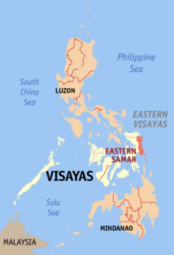
Eastern Samar
| Eastern Samar | |||
|---|---|---|---|
| — Province — | |||
|
|||
 |
|||
| Coordinates: | |||
| Country | |||
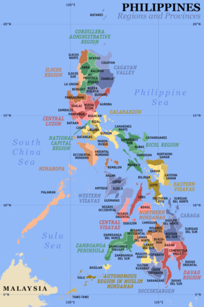
| Region | Eastern Visayas (Region VIII) | ||
| Founded | June 19, 1965 | ||
| Capital | Borongan City | ||
| Government | |||
| - Governor | Conrado B. Nicart Jr. (Nacionalista) | ||
| Area | |||
| - Total | 4,640.73 km2 (1,791.8 sq mi) | ||
| Area rank | 25th out of 80 | ||
| Population (2007) | |||
| - Total | 405,114 | ||
| - Rank | 60th out of 80 | ||
| - Density | 87.3/km2 (226.1/sq mi) | ||
| - Density rank | 68th out of 80 | ||
| Divisions | |||
| - Independent cities | 0 | ||
| - Component cities | 1 | ||
| - Municipalities | 22 | ||
| - Barangays | 597 | ||
| - Districts | Lone district of Eastern Samar | ||
| Time zone | PHT (UTC+8) | ||
| ZIP Code | |||
| Spoken languages | Waray-Waray | ||

Eastern Samar (Filipino:Silangang Samar) is a province of the Philippines located in the Eastern Visayas region. Its capital is the city of Borongan.
Contents |
Location
It is located at the eastern portion of the island of Samar. Bordering the province to the north is Northern Samar and to the west is Samar province. Eastern Samar faces the Philippine Sea to the east, and Leyte Gulf to the south.
History
The province of Eastern Samar was created from Samar by Republic Act No. 4221 on June 19, 1965.
Geography
Demographics
The province has a population of 375,822 as of the 2000 census. This makes it the 20th lowest populated province. The population density is 87 people per km². The common language is Waray.
Physical
The province occupies a total land area of 4,470.75 km2. It is bounded on the north by Northern Samar, on the east by the Philippine Sea, on the west by Samar, and on the south by the Leyte Gulf.
Political
Eastern Samar is subdivided into 22 municipalities and one city.
City
- Borongan City
Municipalities
|
|
Transportation
AIR
- Currently, there are no airline operations in the province after Seair ceased operations in Borongan. However, the ongoing rehabilitation of Guiuan airport which was notable for serving during the WWII, even housing the famed Enola Gay bomber, has attracted 2 major airlines to consider investing airline services to a rising tourist attraction the province, Calicoan Island. It is a recently discovered world-class surfing destination and also has white sand beaches, lagoons, towering cliffs perfect for hikes and rock-climbing and an extensive chamber of caves.
SEA
- There are a number of ports in Eastern Samar that caters mainly to minor sea vessels in the area. There is hope that ports would be developed for public transportation.
LAND
- Bus transit is the primary public land transport to the province from Manila passing through the Pan-Philippine Highway (Maharlika Highway) and through (Western) Samar. There are also vans or jeepneys from Tacloban City going to the different municipalities of the province. The public mode of transit in the province are jeepneys, multicabs, motor tricycles and pedicabs.
Economy
Livelihood
The main product of the province is Copra. Local agriculture includes maize, rice, sugarcane, and various other vegetables.
References
External links
|
|||||